Why Two Beaches a Few Kilometres Apart Surf Differently
, 7 min read
The same swell can line up at one beach and stay soft at the next. Between the buoy and the sand, waves shoal, bend, break on banks, and run through tide and current.
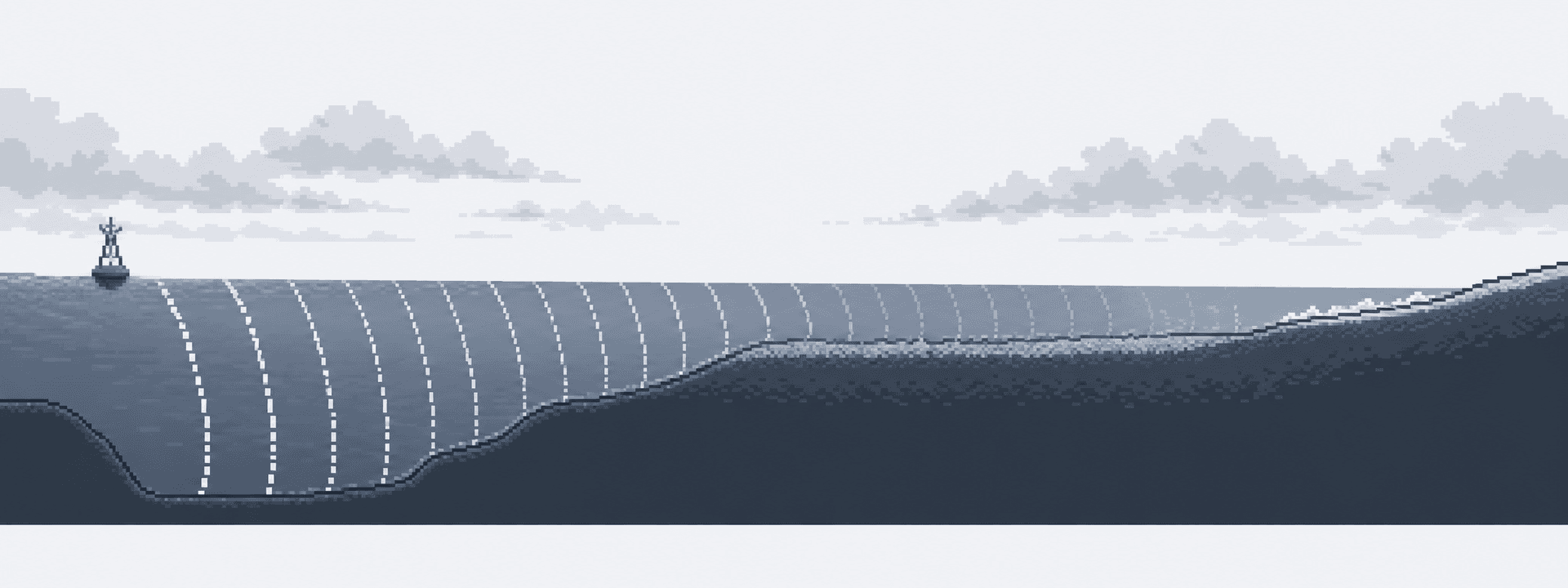
A swell can pass an offshore buoy, reach the Dutch or Belgian coast, and produce different surf within a few kilometres. One beach lines up. Another stays soft. A harbour arm blocks one direction and accelerates current in another. A shallow bank spends the energy before it reaches shore. This piece explains what happens between that buoy and the beach: shoaling, refraction, banks, tide, and current.
What happens as waves enter shallow water?
Wave height, period, direction, and wind are the sea you start with. Between that open water and the sand, waves cross uneven depth. They shoal: as the bottom comes up, wavelength shortens and height can grow until the wave breaks. They refract: the part of the crest in shallower water slows, so the wave front bends. They spread and lose energy to friction. They can break over a bank and arrive inside as leftover chop.
A single regional picture cannot reproduce Scheveningen harbour, the bars at Egmond, the engineered coast at Camperduin, the Flemish Banks, and the broad western Belgian beaches. Each of those bottoms does a different job to the same incoming sea.
How do banks and structures split two nearby beaches?
The bank in front of a beach moves. Storms shift bars. Nourishment and harbour works reshape the slope. Intertidal bars can walk tens of metres within weeks. Belgium is just as varied. Mariakerke is nourished and groyned. Groenendijk near Nieuwpoort has several natural intertidal bars. De Panne has a broad, gently sloping ridge-and-runnel beach. Oostende and Blankenberge are shaped by harbour structures.
Wijk and IJmuiden can share offshore swell while the harbour moles change shelter and breaking height. Domburg wraps around a curved, tide-affected coast. De Koog and Paal 17 sit on the same Texel island and still need their own last stretch. The named lists live on the Netherlands and Belgium hubs.
How do tide and current finish the trip?
Belgium's spring tidal range reaches about five metres. Nearshore currents can exceed one metre per second. The same water height can arrive on the flood, leave on the ebb, or sit near slack. Wind and pressure can push the actual level away from the astronomical prediction.
Current matters most where depth and structures concentrate it. Harbour jetties can accelerate the flood and spin eddies. Time-varying depth and current can change local wave height and period on the way in. “High tide” names a clock. The surf question is where that water sits on this bank, and which way it is running.
What should you trust when two beaches disagree?
Local knowledge has a job: which bank tends to work, when a harbour corner stays clean, how a swell behaves after the turn of the tide. That knowledge is also conditional. Banks move. Reports come from different boards, abilities, and parts of the beach. A good session is evidence for that time and place.
When the local picture is thin, treat the forecast as thinner. An offshore buoy can be fresh and still sit too deep or too sheltered for your break. Two models can disagree on a northwesterly swell entering the North Sea. The practical standard is to forecast the named break, and to leave room for the gap between the buoy and the sand.
Related
Why Height and Period Belong to the Same Wave Train
10 August 2026, 5 min read
A mixed North Sea often carries wind chop and a swell train at once. Height in metres and period in seconds only describe a real sea when they belong to the same train.
How Tide Opens the Flemish Banks
9 July 2026, 6 min read
On the western Belgian sandbanks, outer crests can take the swell at low water. Rising tide puts water over those crests and can turn the same sea into a session.
What a Wave Buoy Can See
12 May 2026, 6 min read
A wave buoy records height, period, and direction in the water it sits in. The rideable face is made in the last shallow stretch, where sandbars, harbour walls, and tide finish the job.